


In brief: we "conquered" about 4000 miles of the US/Canadian
highways, lost few pounds of bodyweight, spent summer in winter
environment, fixed and climbed about 3000 feet of fixed ropes,
climbed to 3200 m (~10700 ft), did not climb THE mountain of 3954 m
(13180 ft), shoot about as much film as fixed ropes - overall, had a
good time and returned back to flatness of Indiana.
Broken car in the middle of nowhere in Minnesota is not too exciting to write about. @#$%#% happens, and we fixed it. But what a wonderful monument honors Minnesota Chicken! ;-)
Mt. Robson Provincial Park is about 250-300 miles from Calgary, at the very border of British Columbia and Alberta. And it's got its name from (guess what!) Mt. Robson, the highest point of Canadian Rockies. The mountain is real serious and darn impressive. You drive to the bottom of it via Transcanadian Highway. Visitors Center is located in 7 miles from the mountain, at the altitude of ~850 meters (2850 ft). And right above it you see this monster - 2 miles of very exposed rock/ice faces, icefalls, etc. The mountain is about 2000 ft higher than anything around it, so it really dominates the area. Because of that the mountain has it's own microclimate, every darn cloud thinks that it has to hang on the summit for a while. Very often (and we had the chance to experience that!) everything around is clear-shiny-sunny, but Mt. Robson is covered with clouds like my chin with beard. That was one of the main reasons we didn't climb it, because for successfull climb one needs 2 days of good weather on the mountain, while we had it mostly down below. The best time weatherwise is August, so we were too early. As the rangers told us, there are years when nobody makes the summit. So we are disappointed, but not too much.
The approach was along the very nice trail in the beatiful valley with gorgeous waterfalls. Heavy packs, gaining altitude, thoughts about "When's the break?" and "Why the hell did I come here?" ;-)). A rest, some water, some food - and life is great again. Hey you, deer, get the hell away from our food, or you're going to become food yourself!
3-days loop to our first summit, Whitehorn Mountain (~11000 ft). Shitty weather, but we're going. The goal is to cross the snowy col to the icefields and set a camp there. From there it's a one day ice climb to the summit. Climbing the col, fixing ropes, and just 200 vertical feet from the top, sitting on a nice safe rock shelf we saw that right where we should go there were big cornices. And where there are no cornices, there's no way to climb. And the cornices look quite bad, especially taking into account a week of snowfalls just before our arrival. Since the weather didn't show any desire to improve (should I say, it snowed quite the opposite), and it was clear that we wouldn't be able to make a summit next day, we decided to get back. Just had some hot tea at 10000 ft. You will not believe that 50 ml (less than 2 oz!) of good cognac, divided for 10 people (that's a sip per person!), could bring one such a pleasure (thanks, Lev, for having this little bottle ;-).
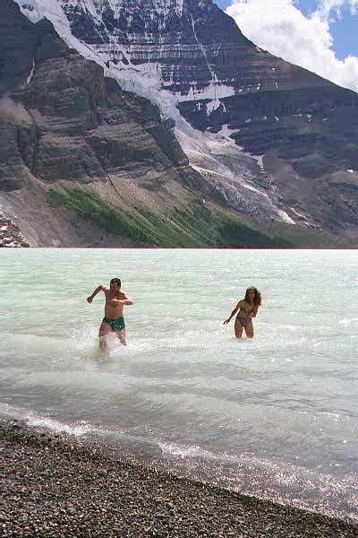
Hourray, a day rest in a shelter on a beutiful Berg Lake! Low altitude, sunny, warm, gorgeous view on a lake and great Mt. Robson just behind it. From the mountain there are 2 icefalls dropping right into the lake, and each icefall has about 3000 ft altitude drop. Quite impressive. Lone iceberg in the lake awaits its Titanics ;-). Swimming in the lake for more than two minutes could permanently freeze your manhood ;-), so we were setting world records in the new Olympic sport "running out from the water". All Canadians and bunch of Frenchmen from the shelter watched the crazy Russians in binoculars, and noone dared to join ;-).
Time to go on. Ascending along the Robson Glacier to about 6700 ft and setting a base camp. From here we were to go to the Resplendent Mountain (11400 ft), and later on to Mt. Robson (13180 ft). Mild signs of the weather getting sour again, but we attempted the climb to Resplendent, hoping to be quick. Mild crevassed glacier, good open ice and/or good snowbridges leads to exposed glaciated ridge with big drops on the other side towards the Visitors Center some 7500 ft below. At about 600 vertical feet below the summit the weather changed instantly. And I mean instantly, in a blink of an eye. All of a sudden a terrible storm came, visibility less than half a rope (!), rain/slit that literally hurts, wind and clouds, and all other pleasantries. It was indeed "Resplendent"e all right. Forget about the summit, and quickly get down, trying to avoid very exposed drop-offs. Fixing and taking off ropes under such rain and wind wasn't the most pleasant thing I've done in life. As a description in a guide book says about Resplendent Mountain, "It's a pleasant day outing" ;-)).
Camp. A blizzard that we escaped is still on top of the mountains, but it's sunny down below. Surprisingly, soaking wet down coat doesn't warm you too much ;-), though it actually was quite warm outside. Getting our stuff dry and spending tons of skin lotion on our windburn faces.
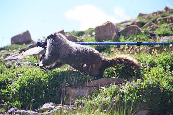
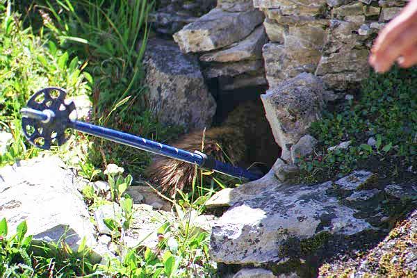
The neat looking clouds (yeah, we've been there, we know that type of "neat" ;-) are still sitting on top of Mt. Robson, so we realized that it's not going to happen. But the surroundings are sunlit, so we are exploring passes and summits around it. A walk to Snowbird pass (~8700 ft), nice trail, no ropes. Marmots! I'm taking his pictures, while he's trying to take my ski pole. And he manages to pull it half-length deep into his hole ;-)). After the daring pole-rescue operation, he comes out of a hole and leaks salt from our sweaty legs. Hope this isn't considered feeding the wildlife ;-)). Whole roll of film of a single marmot. The end of the day - nude swimming of 3 men and one beautiful woman in a nice warm little lake, with lusty marmots envying us (and since I didn't capture it on camera, all the readers are welcome to envy us, too ;-)).
Lynx Mountain (~10700 ft). Next time I'll go, I'll suggest to rename it to Netscape Mountain ;-)). Morraine, glacier, big bergschrund with snow bridge, 9 fixed ropes on mostly covered glacier, and then another 1000 vertical feet on a rocky ridge. A ridge had couple nasty gendarms, loose rocks and other pleasantries. With the added bonus of about 2000 ft of vertical drop-off on the other side of the ridge. Quite impressive, should I say. The last record in the summit register was dated 1992. Our hopes for easy descend to Snowbird pass didn't come true, so we had to descend along the ascend route, bypassing the nasty ridge. As a result, another "pleasant day outing" turned out to be a long 17.5 hour day ;-).
And then after some more wondering on nearby glaciers it was time to go back. Last supper (God, were we hungry!), coffee-and-cream liquor (made on the spot from pure ethanol, water and Instant Cocoa mix) and raspbery liquor (same technique from Crystal Light ;-)... Last nude swim and we hit the cars. And then there was a long drive home, very much enjoyed and appreciated stops at my friends in Minneapolis, Madison and Chicago (thank God their wives are great cooks!), and finally the beautifully-flat home of Boilermaikers, with my Mom's cakes waiting for me.

